|
|
作者:Flyingis
ArcEngine Geometry庫定義了基本幾何圖形的矢量表達形式,頂級的幾何圖形有Points、Multipoints、Polylines、Polygons、Multipatches,Geodatabase和繪圖系統使用這些幾何圖形來定義其他各種形狀的特征和圖形,提供了編輯圖形的操作方法和地圖符號系統符號化特征數據的途徑。
Geometry庫中幾個核心類和接口構成了Geometry對象的基本框架。
GeometryEnvironment
GeometryEnvironment提供了從不同的輸入、設置或獲取全局變量來創建幾何圖形的方法,以便控制geometry方法的行為。GeometryEnvironment對象是一個單例對象。
 public IPolyline TestGeometryEnvironment() public IPolyline TestGeometryEnvironment()
   { {
 ISpatialReferenceFactory spatialReferenceFactory = new SpatialReferenceEnvironmentClass(); ISpatialReferenceFactory spatialReferenceFactory = new SpatialReferenceEnvironmentClass();
//Create a projected coordinate system and define its domain, resolution, and x,y tolerance.
ISpatialReferenceResolution spatialReferenceResolution = spatialReferenceFactory.CreateProjectedCoordinateSystem((int)esriSRProjCSType.esriSRProjCS_NAD1983UTM_11N) as ISpatialReferenceResolution;
spatialReferenceResolution.ConstructFromHorizon();
ISpatialReferenceTolerance spatialReferenceTolerance = spatialReferenceResolution as ISpatialReferenceTolerance;
spatialReferenceTolerance.SetDefaultXYTolerance();
ISpatialReference spatialReference = spatialReferenceResolution as ISpatialReference;
//Create an array of WKSPoint structures starting in the middle of the x,y domain of the
//projected coordinate system.
double xMin;
double xMax;
double yMin;
double yMax;
spatialReference.GetDomain(out xMin, out xMax, out yMin, out yMax);
double xFactor = (xMin + xMax) * 0.5;
double yFactor = (yMin + yMax) * 0.5;
WKSPoint[] wksPoints = new WKSPoint[10];
for (int i = 0; i < wksPoints.Length; i++)
  { {
wksPoints[i].X = xFactor + i;
wksPoints[i].Y = yFactor + i;
 } }
IPointCollection4 pointCollection = new PolylineClass();
IGeometryBridge2 geometryBridge = new GeometryEnvironmentClass();
geometryBridge.AddWKSPoints(pointCollection, ref wksPoints);
IPolyline polyline = pointCollection as IPolyline;
polyline.SpatialReference = spatialReference;
return polyline;
 } }
new GeometryEnvironmentClass僅僅是創建了一個指向已存在的GeometryEnvironmentClass的引用。注意IGeometryBridge2接口的使用,addWKSPoints方法將WKSPoint二維點添加到PointCollection中,用于構建path、ring、polyline、polygon,或增加新點到Multipoint、TriangleFan、TriangleStrip。在Geometry庫中,除了IGeometryBridge2還有IGeometryBridge接口,后者繼承了前者,增加了一些編輯功能(添加點、插入點、重置點、分段等)。
GeometryBag
GeometryBag是支持IGeometry接口的幾何對象引用的集合,任何幾何對象都可以通過IGeometryCollection接口添加到GeometryBag中,但是在使用拓撲操作的時候,需要注意不同類型的幾何類型可能會有相互不兼容的情況。在向GeometryBag中添加幾何對象的時候,GeometryBag對象需要指定空間參考,添加到其中的幾何對象均擁有和GeometryBag對象一樣的空間參考。
private IPolygon GeometryBag_Example(IFeatureClass featureClass)
{
//Check input objects.
if (featureClass == null)
{
return null;
}
IGeoDataset geoDataset = featureClass as IGeoDataset;
ISpatialFilter queryFilter = new SpatialFilterClass();
//Set the properties of the spatial filter here.
IGeometry geometryBag = new GeometryBagClass();
//Define the spatial reference of the bag before adding geometries to it.
geometryBag.SpatialReference = geoDataset.SpatialReference;
//Use a nonrecycling cursor so each returned geometry is a separate object.
IFeatureCursor featureCursor = featureClass.Search(queryFilter, false);
IGeometryCollection geometryCollection = geometryBag as IGeometryCollection;
IFeature currentFeature = featureCursor.NextFeature();
while (currentFeature != null)
{
//Add a reference to this feature's geometry into the bag.
//You don't specify the before or after geometry (missing),
//so the currentFeature.Shape IGeometry is added to the end of the geometryCollection.
object missing = Type.Missing;
geometryCollection.AddGeometry(currentFeature.Shape, ref missing, ref missing);
currentFeature = featureCursor.NextFeature();
}
// Create the polygon that will be the union of the features returned from the search cursor.
// The spatial reference of this feature does not need to be set ahead of time. The
// ConstructUnion method defines the constructed polygon's spatial reference to be the same as
// the input geometry bag.
ITopologicalOperator unionedPolygon = new PolygonClass();
unionedPolygon.ConstructUnion(geometryBag as IEnumGeometry);
return unionedPolygon as IPolygon;
}
Points
一個點包括X、Y坐標,同時可以增加M、Z值及ID屬性來擴展點的功能。
Multipoints
點的集合,多點組成Multipoint幾何類型,使用multipoint對象實現了的IPointCollection接口可以訪問所有的點元素,這些點同樣可以擁有M、Z值及ID屬性來獲得更多的地理空間內涵。
下面列舉一個例子,通過一個已知的polyline來定義一個新的multipart polyline。
public IPolyline ConstructMultiPartPolyline(IPolyline inputPolyline)
{
IGeometry outGeometry = new PolylineClass();
//Always associate new, top-level geometries with an appropriate spatial reference.
outGeometry.SpatialReference = inputPolyline.SpatialReference;
IGeometryCollection geometryCollection = outGeometry as IGeometryCollection;
ISegmentCollection segmentCollection = inputPolyline as ISegmentCollection;
//Iterate over existing polyline segments using a segment enumerator.
IEnumSegment segments = segmentCollection.EnumSegments;
ISegment currentSegment;
int partIndex = 0;;
int segmentIndex = 0;;
segments.Next(out currentSegment,ref partIndex, ref segmentIndex);
while(currentSegment != null)
{
ILine normal = new LineClass();
//Geometry methods with _Query_ in their name expect to modify existing geometries.
//In this case, the QueryNormal method modifies an existing line
//segment (normal) to be the normal vector to
//currentSegment at the specified location along currentSegment.
currentSegment.QueryNormal(esriSegmentExtension.esriNoExtension, 0.5, true, currentSegment.Length / 3, normal);
//Since each normal vector is not connected to others, create a new path for each one.
ISegmentCollection newPath = new PathClass();
object missing = Type.Missing;
newPath.AddSegment(normal as ISegment, ref missing, ref missing);
//The spatial reference associated with geometryCollection will be assigned to all incoming paths and segments.
geometryCollection.AddGeometry(newPath as IGeometry, ref missing, ref missing);
segments.Next(out currentSegment,ref partIndex, ref segmentIndex);
}
//The geometryCollection now contains the new, multipart polyline.
return geometryCollection as IPolyline;
}
ISegment接口的QueryNormal方法用來在弧段上的某一點生成該弧段的法線,指定其長度,這樣就生成了新的segment,并且多個path添加到geometryCollection中,以IPolyline的形式返回。
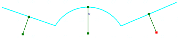
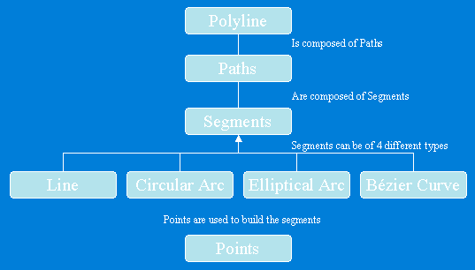
Polylines
Polylines是有序path組成的集合,可以擁有M、Z和ID屬性值。Polyline對象的IPointCollection接口包含了所有節點的復制,IGeometryCollection接口可以獲取polyline的paths,ISegmentCollection接口可以獲取polyline的segments。
Polyline結構圖
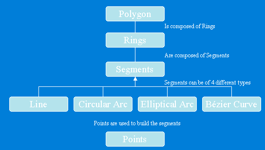
Polygons
Polygon是一系列rings組成的集合,可以擁有M、Z和ID屬性值。每一個ring由一個或多個segment組成,Polygon或ring對象的IPointCollection接口包含了所有節點的復制,IGeometryCollection接口可以獲取polygon的rings,ISegmentCollection接口可以獲取polygon的segments。
Polygon結構圖
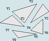
Multipatch
Multipatch用于描述3D面狀幾何類型,由一系列的矢量三角形構成,如果其中的part是一個ring,那么它必須是封閉的,第一個節點和最后一個節點相同,另外每個part所包含節點的順序非常重要,Inner Rings在Outer Rings之后,代表單個表面patch的一系列rings必須由第一個ring開始。
在9.0以后的開發包中,使用IGeneralMultiPatchCreator創建新的Multipatch,IGeometryMaterial進行材質貼圖。
public IMultiPatch CreateMultipatch()
{
//Prepare the geometry material list.
IGeometryMaterial texture = new GeometryMaterialClass();
texture.TextureImage = "C:\\Temp\\MyImage.bmp";
IGeometryMaterialList materialList = new GeometryMaterialListClass();
materialList.AddMaterial(texture);
//Create the multipatch.
IGeneralMultiPatchCreator multiPatchCreator = new GeneralMultiPatchCreatorClass();
multiPatchCreator.Init(4, 1, false, false, false, 4, materialList);
//Set up part.
//Could also use a Ring or a TriangleFan.
multiPatchCreator.SetPatchType(0, esriPatchType.esriPatchTypeTriangleStrip);
multiPatchCreator.SetMaterialIndex(0, 0);
multiPatchCreator.SetPatchPointIndex(0, 0);
multiPatchCreator.SetPatchTexturePointIndex(0, 0);
//Set real-world points.
WKSPointZ upperLeft = new WKSPointZ();
WKSPointZ lowerLeft = new WKSPointZ();
WKSPointZ upperRight = new WKSPointZ();
WKSPointZ lowerRight = new WKSPointZ();
upperLeft.X = 0;
upperLeft.Y = 0;
upperLeft.Z = 0;
upperRight.X = 300;
upperRight.Y = 0;
upperRight.Z = 0;
lowerLeft.X = 0;
lowerLeft.Y = 0;
lowerLeft.Z = -100;
lowerRight.X = 300;
lowerRight.Y = 1;
lowerRight.Z = -100;
multiPatchCreator.SetWKSPointZ(0, ref upperRight);
multiPatchCreator.SetWKSPointZ(1, ref lowerRight);
multiPatchCreator.SetWKSPointZ(2, ref upperLeft);
multiPatchCreator.SetWKSPointZ(3, ref lowerLeft);
//Set texture points.
//Set the texture coordinates for a panel.
WKSPoint textureUpperLeft = new WKSPoint();
WKSPoint textureLowerLeft = new WKSPoint();
WKSPoint textureUpperRight = new WKSPoint();
WKSPoint textureLowerRight = new WKSPoint();
textureUpperLeft.X = 0;
textureUpperLeft.Y = 0;
textureUpperRight.X = 1;
textureUpperRight.Y = 0;
textureLowerLeft.X = 0;
textureLowerLeft.Y = 1;
textureLowerRight.X = 1;
textureLowerRight.Y = 1;
multiPatchCreator.SetTextureWKSPoint(0, ref textureUpperRight);
multiPatchCreator.SetTextureWKSPoint(1, ref textureLowerRight);
multiPatchCreator.SetTextureWKSPoint(2, ref textureUpperLeft);
multiPatchCreator.SetTextureWKSPoint(3, ref textureLowerLeft);
IMultiPatch multiPatch = multiPatchCreator.CreateMultiPatch() as IMultiPatch;
return multiPatch;
}
參考資料:ArcEngine 9.2幫助文檔

|